Lightning Viewer Frequently Asked Questions
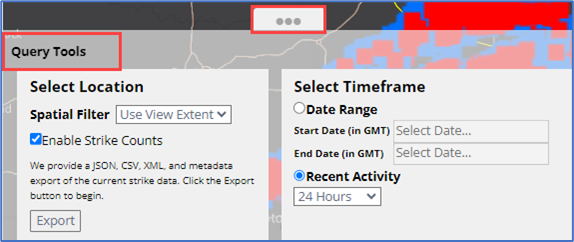
Where can I find the Query Tools?
Go to the bottom of the map and click on the three ellipses.
Why are the strike counts not displayed when I am zoomed into an area/location?
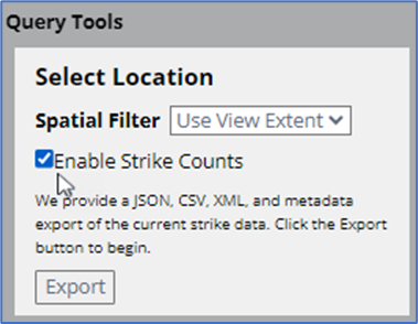
Go to the Query Tools section and ensure Enable Strike Counts is selected.
Why are there no lightning strike counts in the Feature Counts table?
Go to the Query Tools section and ensure Enable Strike Counts is selected.
How can I find lighting strike counts for a specific area/location?
Go to the Drawing Tools → select shape type → click or tap on the map to draw the area. The number of strike counts will appear within the Feature Counts.
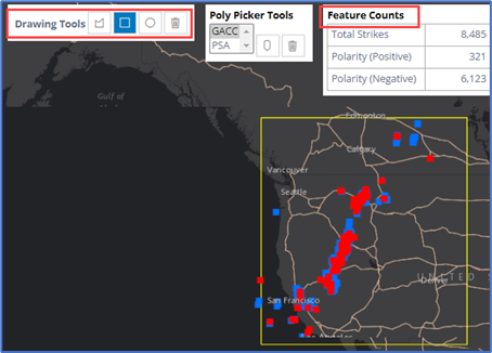
How do I use the GACC picker to see strike counts?
Go to the Poly Picker Tools → choose GACC → click the Pick a Polygon icon → click on the GACC area. The Feature Counts will automatically update.
How do I export a map?
Maps cannot be exported from Lightning Viewer; however, the option is available in SituationAnalyst (SA).
How do I export strike counts?
Go to the Query Tools → click the Export button → save the file, click the download icon at the top to the browser to open the file.
How do I access Historical Lightning data?
Go to the Query Tools and under the Select Timeframe section choose up to 7 days using:
- Date Range: enter start and end date or,
- Recent Activity: select a range from 15 minutes to 7 days.
Where do I find Lightning Data beyond 7 days?
Archived lightning data beyond 7 days is only available through Earth Networks or contact the helpdesk for assistance.
