SituationAnalyst (SA) Frequently Asked Questions
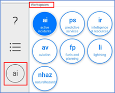
How do I change my Workspace?
Go to the bottom left navigation pane, click the Workspace icon, and click on the new workspace.
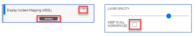
How do I add Layers from one workspace to another workspace?
Click on the Layer, click Details, and check the Keep in All Workspaces box.
Can I save the layers I’ve added in this session to use in the next session I open?
No, layers are reset to the default state when the application closes.
Where do I find the Briefing Tool?
From the top left navigation pane, click on the Briefing Tool icon

Where do I find weather data?
Click on the workspace icon → click Predictive Service (ps) workspace → select either NWS or NowCoast layers.
Where do I find lightning data?
Click the Lightning (li) workspace → select a BLM Lightning Service layer → click the Legend icon to see specific lighting strike data.
Where do I find archived lightning data?
Archived lightning data beyond 7 days is only available through Earth Networks or contact the helpdesk for assistance.
How do I access the Lightning Viewer application from the SA application?
Lightning Viewer application is not accessible within the SA application.
Where can I find ATU (Automated Telemetry Units) data?
Go to Aviation (av) workspace → zoom map to the designate location → click the necessary ATU layer(s).
Where can I find imagery/video collected for a specific incident?
Go to the intelligence Resources (IR) workspace → under Airborne Intel header click on Incident → in the search bar type in the Incident number or Aircraft Tail number.
Where do I find historical fire perimeter data?
WFIGs data layers are visible in the Active Incidents, Predictive Services, Aviation, or Fuel and Planning workspace. Click WFIG – Wildland Fire Perimeters Current Year or WFIG – Wildland Fire Parameters Current Decade for the last 10 years.
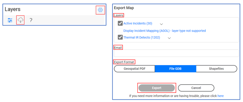
How do I export/download data?
Select the needed layers → click the gear icon next to the title Layers → click the Cloud icon → select needed Layers → enter e-mail and press tab button → select either File GDB or Shapefiles → click Export.
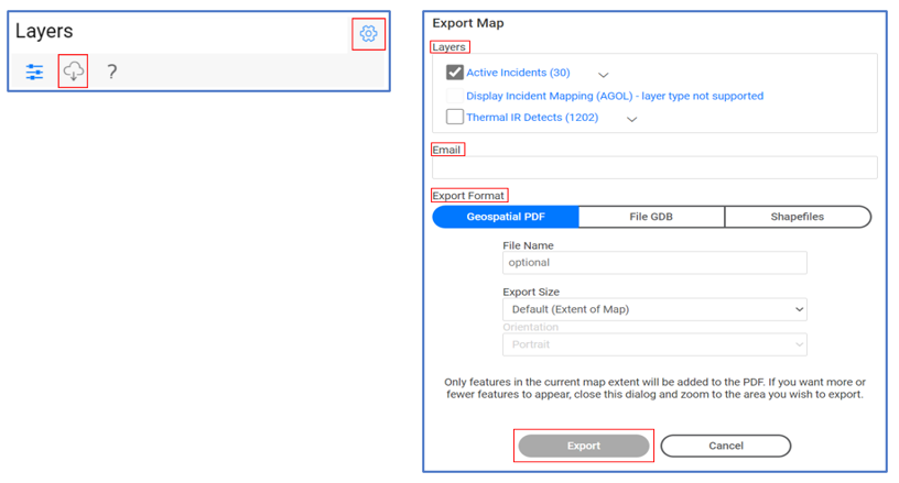
How do I export a Geospatial pdf (GeoPDF) map?
Select the needed layers → click the gear icon next to the title Layers → click the Cloud icon → select needed Layers → enter e-mail and press tab button → select Geospatial PDF → click Export.
Why is the export button greyed out?
Be sure to press the tab button after entering your e-mail.
Where is the map or data I exported?
A link will be sent to the provided e-mail, typically within 15 minutes.
Where can I find the data source for the layers in SA?
Data sources are currently not available.
